North Dakota Township Officers Association - FEMA - ND DES
FEMA - ND DES
FEMA - NDDES Township Handout - (2023-12-18) PDF <== CLICK FOR PRINTABLE FORM
Township Handout
Disaster Recovery (DR) – FEMA Public Assistance (PA)
Please note that this handout is a supplementary document to FEMA Guidance and Policy and should only be used as a reference. See your County FEMA Applicant Agent for further guidance.
Additional PA guidance can be found at the NDDES Grants Website: Public Assistance - grants.des.nd.gov
Who is your Point of Contact During a Federally Declared Event?
All Counties are assigned one point of contact to manage the FEMA grant. Your County FEMA Applicant Agent (AA) could be the Emergency Manager, Highway Superintendent or Auditor. These people are invited to attend training provided by the North Dakota Department of Emergency Services (NDDES) multiple times a year and will work hand in hand with NDDES staff during the event.
Type of Incident
All disasters are triggered by an event. The event could be triggered by a storm, flooding, or a tornado. Claimed damages must derive from the event that was declared.
Incident Period
An incident period will be established once a Federal Event is declared. Claimed damages must have occurred during the established incident period. Damages occurring outside of the incident period are not eligible for funding.
Pre-Disaster Condition
Public Assistance Funding is always based on pre-disaster size, capacity and function. Facilities can only be repaired to their original pre-disaster condition/design unless townships participate in Hazard Mitigation (See Hazard Mitigation Section for additional details).
Eligible facilities – Must meet 6 criteria.
- Be a result of the declared incident (Flooding or Blizzard or Summer Storm)
- Be within Designated Area (County, Tribal or Private Non-Profit)
- Be the legal responsibility of the agency requesting assistance.
- Be a publicly owned improved structure.
- Be a maintained structure.
- Be in use at the time of the event.
Ineligible Facilities
- Unimproved property (e.g., a hillside or slope, forest, natural channel bank)
- Agricultural Land
- Private roads and trails
- Mechanical damages to road
- Unmaintained roads and structures
Timelines
Townships have 60 days from the Recovery Scoping Meeting to identify any damages from the incident. Please identify your damages to your county point of contact. Any damages not identified within the 60-day period may be considered ineligible for PA funding.
Once work on a project is 100% complete, the AA must submit documentation for the project within 90 days of the Recovery Scoping Meeting or within 90 days of the work completion date, whichever is later.
Maintenance Records
FEMA requires maintenance records to demonstrate that the facility was regularly maintained and in good operational order prior to the incident. Townships must provide maintenance records or documentation establishing a routine maintenance program. It is recommended that townships keep a file of all invoices for repair and maintenance each calendar year.
Work Completed and Work to be Completed Damages
All damaged sites must be identified as work completed or work to be completed.
Physical site inspections may no longer be necessary under the FEMA program. Damages can be validated through photos and damage descriptions. If there are discrepancies, a physical site inspection by the State or FEMA will be required.
Work Completed
Work Completed costs are costs that have been completed prior to a physical or virtual site inspection. Work completed costs will be based on actual costs. Invoices are required to establish the cost that has been invested into the site.
Documentation required for Work Completed:
- Photos of your damages
- Disposal location for any debris (Debris cannot be disposed within the 100-year floodplain)
- Damaged culverts
- Vegetative debris
- Trees and branches
- Cubic yards of debris must be calculated - Keep track of the yardage that is being removed.
- Any permits obtained during the burning or burying of debris.
- Map of your damaged sites – Number your sites according to site tracker guidance
- You will also need to supply the material source location and certifications in the form of SHPO certifications or NDDOT material source certifications.
- Invoices for work completed must include the following:
- Quantity of material placed.
- Identify location (Section Lines)
- Identify site #
- Invoice date
- Invoice #
- Name of Contractor
- Equipment used to include hours; hours are necessary when completing large sites (Culvert Repairs/Major Washouts). Equipment hours are NOT necessary for simple gravel placement.
- Dates of work
See below for an example of an Invoice.

Work to be Completed
Work-to-be-completed costs are costs that have not been completed prior to a virtual or physical site inspection. Work to be completed costs will be based on estimates. Once your damages have been identified, an estimate of damages and cost will be submitted by NDDES to FEMA for approval. Future invoices for these sites will need to be kept for the closeout process.
Documentation required for Work to be Completed:
- Material Cost Sheets – Additional blank forms can be obtained from your AA point of contact.
- Please provide estimates for all materials identified during your site inspection.
- Important to include estimates for culverts as well.
- For larger WTBC sites ($10,000.00+)
- Seek out local quotes from contractors.
- Engineer’s estimates are generally acceptable by FEMA.
- Document how quotes were requested.
- Seek out 3 quotes if possible.
- Map of your damaged sites – Number your sites according to site tracker guidance. If you have repeated damage at a site, number it the same for each event. This will assist us in possible future mitigation.
- Photos of your damages at the time of the event (It can be difficult to see damages after blading has occurred at your sites)
Hazard Mitigation
FEMA has authority to provide PA funding for cost-effective hazard mitigation measures for facilities damaged by the incident.
Mitigation efforts must be cost effective and reduce the potential of future similar disaster damages to the eligible facility, (a facility is a road, culvert, building, ballpark, bridge etc… all are classified as a facility under FEMA).
The Mitigation proposal cost cannot exceed 100% of the eligible damage to your site.
Hazard Mitigation Examples:
- Installing Rip Rap
- Upsizing culverts with an appropriate H&H study
- Geotextile Separation Fabric
- CMP end sections, headwalls and wingwalls
Mitigation proposal must protect a damaged element.
- Installing rip rap to prevent surface gravel wash does NOT protect the damaged element.
- Installing rip rap to protect a damaged culvert does protect the damaged element.
Hazard Mitigation proposals are required to go through an additional FEMA review. You are also responsible for the additional local share of your hazard mitigation.
It is always best to discuss your hazard mitigation proposals with your FEMA point of contact, site inspector or PDMG before conducting the work.
Capturing Damage Information
After the event (disaster) is over and you can safely travel your roads, it is important to collect your damage information.
Items to capture:
- Description of the facility.
- Exact dimensions of the damage, including the specific materials and the size/capacity/model of the damaged components
- Cause of damage, confirm damages were caused by the event and damages occurred during the incident period.
- Photos and/or sketches of site to capture profile and cross-sectional perspectives.
GPS coordinates are required. GPS coordinates should be taken at the beginning and the end of your damages. If cannot get to the end point, if possible, take from the North end of a North- South Road, the East end of an East-West Road. GPS coordinates are also required for each damaged culvert.
Photos of Damages
Photos of your damages should be taken from multiple angles to ensure that all damages are being captured adequately. It is better to have too many photos than not enough. Ensure good lighting and perspective to allow adequate review of your damaged photos.
When taking photos, if possible, add notes or captions of details to each photo, including perspective (e.g., looking east or west), so reviewers can reference the site to the photo in making the determination as to event damage.
NDDES uses the pictures you provide to determine your loss. Without legitimate, quality pictures FEMA funding may be jeopardized.
Damaged Photo Examples of Gravel Roads:

Above photo does not show gravel wash (Poor)
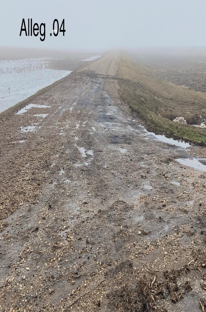
The above photo does show gravel wash (Good)
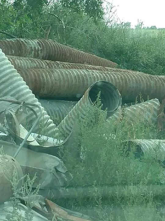
Culverts
Just like gravel roads, culverts need to be maintained and in good working order at the time of the event.
Upsizing or downsizing the diameter of a culvert is considered ineligible unless a hydrologic and hydraulic (H&H) study is completed on the damaged culvert. In addition to the H&H study, the culvert must be damaged by the declared event and during the event incident period.
Culverts that have failed due to rust or lack of maintenance will not be considered eligible for FEMA funding. Therefore costs associated with an H&H study will not be considered eligible as well. Evidence of erosion and damage to the culvert is required for eligibility.
Disposal locations of culverts are required to include GPS and address. Culverts cannot be disposed of within the floodway or floodplain.
Please consult your FEMA County Applicant Agent before upsizing or downsizing culverts.
Damaged Photos Examples of Culverts
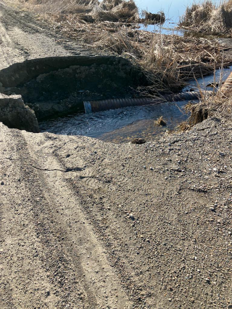
The above photo captures erosion and separated culvert (Good)
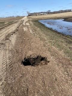
Photo identifies hole in the road. Damages Typical of a rusted culvert or animal damage (Poor and not eligible without additional photographic evidence – Have contractor take pictures of when repairing…)
Take photos of damaged culverts to identify the condition if excavated.
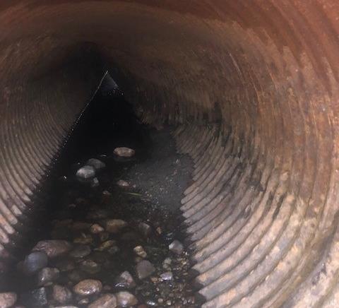
Take photos of inside of culvert prior to excavation to determine the condition.
Traffic-Induced Surface Damage Resulting from Re-opening Road Prematurely
FEMA Polic FP 104-009-13
To help avoid damage to roads that have been inundated, Applicants should allow time for saturated soil to dry out prior to reopening roads to normal traffic to prevent surface damage caused by reopening roads prematurely. Such damage is traffic-induced, not disaster-related, and should be
expected on a saturated roadbed. In addition to not being a result of the declared disaster, surface damage from reopening roads to normal traffic prematurely may constitute negligence and, therefore, may not be eligible for repair assistance from PA. Exceptions include surface damage caused by emergency vehicles performing eligible debris removal or other emergency work under PA necessary as a result of the declared event or single-access roads that the Applicant determined were required to be reopened for emergency response purposes due to lack of detour/alternate routes. In such cases, the Applicant must provide documentation to justify reopening the road prematurely.
Inundated Roads
FEMA has established strict guidelines for federal participation for inundated gravel roads that create long-term inundation. Inundated roads may be eligible for an emergency grade raise/alternate route or a permanent grade raise/alternate route if certain criteria are met.
- The roadway is fully inundated and provides sole access to a primary residence, and there is no alternate route to accommodate emergency vehicles.
- The submerged section of road causes an unreasonably long detour that creates a threat to human life and safety.
- The submerged section of road is in a designated basin area.
- The basin flooding is directly attributed to the declared major disaster event and does not represent the culmination of multiple meteorological events that have caused excessive run-off into the basin over an extended period of time; and
- The basin flooding results in long-term loss of use of critical routes. Information to support the basin flooding was directly attributed to the declared major disaster event and the long-term loss of use of critical routes.
- Information showing that the water elevation in the basin has reached historically high levels; that the rise in the water level occurred during the designated incident period; historic water level elevation and rainfall intensity records; and/or maintenance reports or other information that provides some historical perspective on events and water levels within the basin.
- For long-term loss of use of critical routes: Information demonstrating the length of time the roadway has been closed to traffic and is projected to remain closed to traffic based on the basin water level elevations that occurred as a direct result of the declared major disaster event.
Applicants must consult NDDES/FEMA and get prior approval for any permanent grade raise. Consult your FEMA County Point of Contact immediately for any inundated roads and see additional guidance.
Permanent Grade Raises will require the following support documentation and engineering analysis.• An engineer or hydrologist certification that the water impacting the inundated roadway will not be going down for a significant period of time.
- A scope of work for the grade raise with the road height justified by an engineer.
- An engineer or hydrologist’s determination of how large the equalization pipe in this road should be, how many pipes might be needed, and where in the road should they be placed.
- An engineer’s verification that the road needs to be armored to ensure it maintains its form and function.
Monitoring Contracted Debris Removal Operations
FEMA requires the Applicant/Township to monitor all contracted debris operations to ensure that the quantities and work claimed are accurate and eligible. This includes documenting debris quantities by types, quantities reduced, reduction methods, and pickup and disposal locations. If the
Applicant does not monitor contracted debris removal operations, it jeopardizes its PA funding for that work.
Contractors do not qualify as monitors. All monitoring must take place at the township or County level.
Disposal locations of debris are required to include GPS and address. Culverts cannot be disposed within the floodway or floodplain.
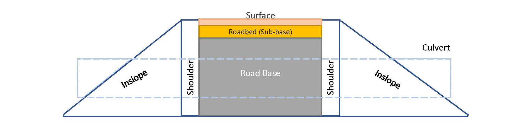
Components of a Road:
Damage descriptions must be quantifiable in order for your costs to be calculated. The dimensions that you identify must cover the Length (L), Width, and Depth (D) of the wash or damaged area. We request that your
- Surface and Subbase: Surface Gravel (CL5) crushed / screened, fines, etc. The top road layers.• L x W x D / 324 = CY (L, W in feet & D in inches). For area, L x W / 9 = SY (L, W in feet).
- Road base: Gravel (CL13), pit run, scoria, shale, etc. Base for surface. Mitigation opportunity using geotextile fabric underneath. • L x W x D / 324 = CY (L, W in feet & D in inches).
- Roadbed: Embankment, clay, etc. The bottom-most layer. • L x W x D / 27 = CY (L, W, D in feet).
- Shoulder: Embankment, clay, etc. Non-sloped portion adjacent to gravel road. • L x W x D / 27 = CY (L, W, D in feet).
- Inslope: Embankment, clay, etc. Sloped portion. Riprap and filter fabric, or wing wall Mitigation may be utilized when bridge or culvert system is present. • L x W x D / 54 = CY (L, W, D in feet).
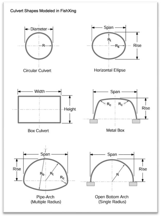
- Culvert: Corrugated Metal Pipe (CMP), Reinforced Concrete Pipe (RCP), Polyethylene Pipe (PEP), box/precast culvert, etc. The shape may be circular, arched, box or bridge. L x Diameter.
Measurements
Use a tape measure to record the length, width, depth and/or diameter of the damaged component. Measure the road length with either a vehicle distance measuring device, distance wheel, GPS or any other accurate unit of measurement.
Township Road Defined
ADMINISTRATIVE RULES, ARTICLE 84-03, Chapter 84-03-01 Distribution to Townships, Section 84-03-01-01. A township road, for purposes of the administration of North Dakota Century Code section 57-50-01, is a public road established pursuant to North Dakota Century Code chapter 24-07 which is an improved road, constructed, maintained, graded, and drained by the township, or county in the case of an unorganized township. A township road includes a street in an unincorporated townsite and does not necessarily have to be surfaced. A sodded road is not a township road. In order for a section line to be a township road it must be graded and drained and be an improved maintained road. A township road is a public road which is not designated as part of a county, state, or federal-aid road system and is not located in an incorporated city. History: Effective
June 1, 1982, General Authority: NDCC 54-27-19.1, Law Implemented: NDCC 54-27-19.
Road Diagram:
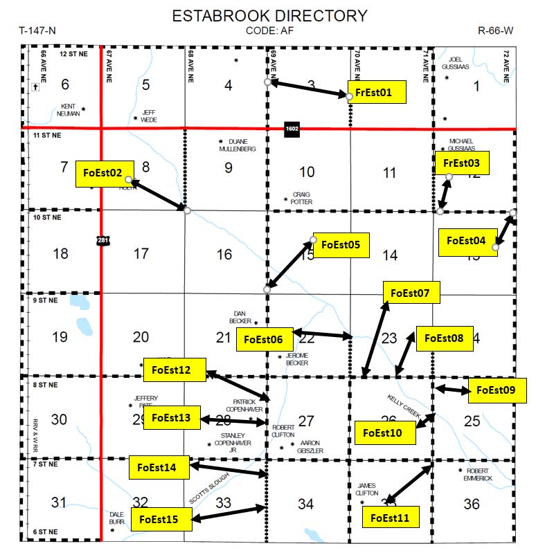
Map of Sites
Townships are required to identify all site locations on their township’s Directory Map and NOT THE PLAT MAP.
Maps must show Street and Avenue numbering, Section numbering, Road Type, Road Numbering (if applicable, FHWA Roads and some County Roads are numbered).
Your AA can provide you with a copy of your Directory Map if you do not have access to one.
Township Required Documentation Checklist
- Site Map: All maps must have clearly visible street numbers.
- Photos and or Sketches: Must be labeled with the site name in some way. Please change the digital file name to reflect the name of your site. Pictures of the damages are required. Pictures after repairs are made do help validate your damages.
- Provide your site tracker to your AA. See site tracker guidance later in the Township handbook.
- Material Cost Sheet – Your AA will have copies of these forms to fill out. This form will be used for your in-place costs for the placement of road material. Prices must include delivery and placement.
- Invoices must be itemized. Lump Sum contracts will not be accepted.
- Material Source: (Aka SHPO) NDDOT or completed emergency material borrow location compliance form from SHPO Office.
- Maintenance Records: Supply your AA with all maintenance and repair records from the previous calendar year.
- Culvert Disposal Site: Memo or letter stating where the culverts are taken after removal, e.g., Bills Recycling Center, 23487 143rd St SE, Nowhere City, ND 58585
- Hazard Mitigation Proposal (HMP): Any requested HMP cannot exceed the cost or estimate to return the damage to pre-disaster condition. Please provide a full description to include costs or pricing of materials. Your state representative can help write your mitigation proposal.
Filling out your site tracker accurately and thoroughly is essential, as this document will set the pace for the writing process of your project worksheets.
Using Your Site Tracker with the Public Assistance Delivery Model
In 2014, FEMA conducted an in-depth analysis of the Public Assistance (PA) program's delivery process. Following months of analysis and restructuring, a new PA Program Delivery Model was designed to meet the needs of applicants by streamlining and categorizing projects. The goal moving forward is to deliver the PA program more efficiently so applicants can receive their funding much faster to rebuild public infrastructure after a disaster. To facilitate these changes, FEMA developed the Grants Manager and Grants Portal tools, which are web-based, project tracking systems
used by FEMA and our stakeholders.
In order to keep your Federal Grant moving forward quickly and efficiently, we are asking you, the applicant, to fill out the attached Site Tracker that your Program Delivery Manager (PDMG) will use to create your Damage Inventory. A Damage Inventory is a comprehensive list of your damaged sites that will get uploaded into the Grants Portal. With the new Program Delivery Model, the Damage Inventory is what the State and FEMA use to develop your Project Worksheets (PWs) so your damaged sites can be approved for funding.
The PA Program Delivery Model no longer requires a site inspection for sites where work has been 100% completed. The site tracker will be used to develop the Damage Description and Dimensions (DDD) and Scope of Work, instead of relying on site inspections. Therefore, it is vital to produce
an accurate site tracker with a detailed DDD.
The following instructions will explain how to fill out this site tracker for use during the Preliminary Damage Assessment (PDA) and Site Inspection processes.
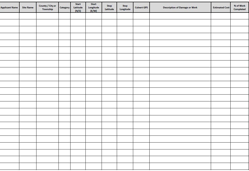
Breaking Down the Site Tracker Columns:
Applicant Name:
This column represents the name of the entity that you represent and the name that you will use to make your Request for Public Assistance (RPA).
Site Name:
Every site is required to have an identifying number. We would like you to use the following guidance when creating your identifying numbers for your sites.
- For County Applicants:
- County Sites: Please use the first 5 letters in your county name followed by the numerical numbering of your site. The Numerical numbering must contain 2 characters. For example: Benson County Site 1 would be Benso01.
- Township Sites: Please use the first and last letters of your county, followed by the first three letters of your township, followed by the numerical numbering of your site. The numerical numbering must contain 2 characters. For example: Benson County, Rock Township Site 1 would be BnRoc01.
- For Applicants other than Counties: Use the first 5 letters in the name of your entity followed by the numerical numbering of your site. The Numerical numbering must contain 2 characters. For example: Devils Lake Site 1 would be Devil01. For those entities whose names do not contain 5 characters, use as many characters as your entity name can provide, followed by the two-character number.
County/City or Township:
- For County Applicants: If the site that was damaged is a county-owned property, please identify as “County”. If the site was a Township Site, please identify the Township name.
- For Applicants other than Counties: Identify the county where your damages are located.
Category:
You will be required to identify the category of work that the damages or work falls under. Just enter in the letter that corresponds with the damages (i.e. A, B, C, etc.)
- Category A: Debris Removal
- Category B: Emergency Protective Measures
- Category C: Roads and Bridges
- Category D: Water Control Facilities
- Category E: Buildings and Equipment
- Category F: Utilities
- Category G: Parks, Recreational and Other Facilities
In some cases, damages and work may not fit clearly in one specific category. Apply the category that best fits your damages/work and your PDMG may need to adjust the category later in the process.
Latitude and Longitude:
You are required to produce a latitude and longitude location of your damaged sites or where your work occurred. The GPS locations must be in the decimal degrees format. Please provide your GPS to the 5ᵗʰ decimal place, i.e., 48.12345, -98.12345.
- Roads: For damaged roads traveling in a west and east direction, take the GPS location on the furthest-most east point of the damage. For damaged roads traveling in a north and south direction, take the GPS location on the furthest most north point of the damage.
- Emergency Protective Measures/Debris: You may have multiple operations throughout your entity where one specific GPS cannot be placed. In these cases, take your GPS at your base of operations.
Description of Damage or Work:
In this column, you will be required to provide a specific description of the damage that occurred at your site and/or the work that was performed during Category B: Emergency Protective Measures.
It is key that you are as descriptive as possible when producing your DDD. Damage descriptions must be measurable and quantifiable.
Below are some examples of how we would like you to describe your damages per site:
- Surface gravel washed from road area 100’ x 22’ x 2”
- Roadbed eroded over area 75’ x 22’ x 4”
- Rip Rap eroded over are 50’ x 6’ x 2’ on the east side
- Inslope eroded over area 50’ x 6’ x 2’/2 on the east side
- 40 LF of 36” CMP eroded around and was displaced without damage
- 40 LF of 36” CMP eroded, washed out, and was damaged beyond repair
Below are some examples of incomplete and complete DDDs:
- Incomplete – Gravel wash 100’ x 18’
- Complete – Gravel washed from road area 100’ x 18’ x 2”
- Incomplete – Culvert washed out
- Complete – 40 LF of 36” CMP eroded around and was displaced without damage
When writing your DDD for Category B work, you will be required to describe what work was completed and what you protected or accomplished.
Below are some examples of how to write a DDD for Category B work:
The city constructed levees from earth, sandbags, and Hesco bags to protect against the threat to life and property of the citizens of Mandan. Force Account utility work crews were mobilized to help flood fighting efforts. They combined with other city employees to man pumps, check dikes and
levees, acquire necessary materials at local businesses in order to keep flood waters under control.
Electrical generators were rented to supply power to operate electric pumps and lights during the flood-fighting effort. Tractors were rented (some donated) and placed at strategic points throughout the city and PTO pumps attached to tractors were used to move large amounts of flood water away from threatened areas.
The utility crew, working with the wastewater crew, acquired ball plugs and placed them at wastewater lift stations to keep flood water from community housing and businesses. Frames were built to guide hoses over dikes and levees from pumps pumping flood water from behind plug dikes and levees in the bay areas.
Sites that are identified as work completed must contain a damage description that allows enough area to fit the cubic yards placed at a site.
Estimated Cost:
You must provide estimated costs per site. These costs should be as accurate as possible; however, it is understood that these costs are estimates because repairs might still need to be completed. You may need to update this section after final invoices are submitted to you. For sites
with estimates that are considered work to be completed, be prepared to produce documentation as to how you derived your estimate.
Percentage of Work Completed
In this column you will need to identify the percentage of work that has been completed at the site. If no work was completed, place 0% in this column. Your PDMG will need this information in order to set up your site visits.
Your PDMG will schedule your recovery scoping meeting (RSM), formally known as the Kick-off meeting, and at this point you will submit your site tracker to your PDMG. Once the RSM is completed, the PDMG will have the responsibility to update the site tracker based on the information that you are submitting to them.
Filling out your site tracker accurately and thoroughly is essential, as this document will set the pace for the writing process of your project worksheets.
Please identify any sites that you are requesting to be made a priority. The state representative assigned to you will help get your priority sites submitted to FEMA if possible. Damaged priority sites could be asphalt streets, sewer systems, lift stations, drainage systems, lagoons, sole
access inundated roads, buildings or bridges.
Filling out your site tracker accurately and thoroughly is essential, as this document will set the pace for the writing process of your project worksheets.